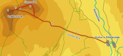
 This is one of the classic Yorkshire walks, climbing Ingleborough from Horton-in-Ribblesdale. Five miles each way, the walk is dominated by two of the three peaks - Ingleborough itself is visible for large parts of the walk, and Pen-y-Ghent dominates the view back along the entire walk.
Our walk passes through Sulber Nick on the way up Ingleborough and then diverts onto the almost deserted summit of Simon's Fell on the way back.
On a busy day detailed instructions for this walk almost feel superfluous - simply follow the hoards heading west out of Horton in Ribblesdale!
Ascent: 1,930ft/ 590m
Length: 10.5 miles/ 17km
Map: Explorer 02 Yorkshire Dales West and South
Last Walked: 20 August 2005
There are a number of places to park in Horton in Ribblesdale. On my last visit it was possible to park behind the pub at the southern end of the village, in a pay and display car park just to the south of the bridge over the River Ribble or in a field just over the river. Of these the first and last mentioned are best for walkers, having a fixed all day fee.
Our directions are going to start from the southern car park, passing the other two as it goes.
![]() From the car park behind the pub turn left and follow the road as it runs north through the village, past the famous Pen-y-Ghent Cafe and the pay and display car park. Follow the road as it turns sharply to the left and crosses over the River Ribble. Follow the road west. When the main road turns sharply to the right, leave it and continue to the west along the road to Horton station.
From the car park behind the pub turn left and follow the road as it runs north through the village, past the famous Pen-y-Ghent Cafe and the pay and display car park. Follow the road as it turns sharply to the left and crosses over the River Ribble. Follow the road west. When the main road turns sharply to the right, leave it and continue to the west along the road to Horton station.
At the station we need to cross over the railway. Take care here - look left, look right and listen for the trains - then cross when you are sure it is safe. On the far side of the railway the path crosses a narrow field. In the next field the path turns slightly to the right and heads for the north ![]() west corner of the field. In the next field it continues on in the same direction until it comes close to the left hand wall and then turns slightly to the left. The path is very obvious in all three of these fields.
west corner of the field. In the next field it continues on in the same direction until it comes close to the left hand wall and then turns slightly to the left. The path is very obvious in all three of these fields.
At the end of the third field we reach the edge of the limestone pavements. Once again the path here is very clear, heading west towards the distant target of Ingleborough. The most distinctive feature of this part of the path is Sulber Nick, where the path runs up a narrow grove in the limestone.
We begin our return trip by retracing our steps down the north eastern slope of Ingleborough, on the rocky staircase. However, we are going to take a diversion onto Simon Fell, so we ignore the turn right onto the path back to Horton, and instead continue on along the ridge, until we reach the point where the main footpath crosses over a wall and turns right to descend rapidly towards Chapel-le-Dale.
This part of the walk takes us off the paths and onto access land. While we are free to walk across this land, there is no guarantee that there will be convenient stiles or gates to allow us to cross walls, so it is best to plan our route to avoid the need to cross potential barriers.
Where the path from Ingleborough turns left, a stone wall continues on along the ridge towards Simon Fell. Do not cross this wall, but instead head along the ridge with this wall on your left. The official summit of Simon Fell is shown just on the opposite side of this wall, but the summit plateau is broad and grassy, with good views to the north and east.